

Tuesday, May 30, 2017
Monday, May 22, 2017

Thursday, May 18, 2017
Migration in the United States, 2009 to 2013
created by Dan Stephen
Cartography and Geovisualization Group , Oregon State University
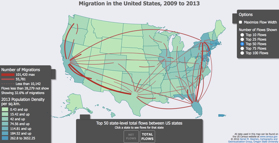
This interactive map displays population shifts within the United States from 2009-2013 using Census data
Monday, May 15, 2017

Thursday, May 11, 2017
Mapping Growing News Deserts

As local newspapers have closed across the country, more and more communities are left with no daily local news outlet at all.
Here are the number of audited daily papers per county, according to research from Ohio University and the Alliance for Audited Media. Because this chart tracks only daily newspapers audited by AAM that meet a minimum penetration level in their markets, some papers may be excluded.
Monday, May 1, 2017
New Additions ICPSR April 30, 2017

New Additions
Updates
- 36498 Population Assessment of Tobacco and Health (PATH) Study [United States] Public-Use Files
http://doi.org/10.3886/ICPSR36498.v5 Question about access? Contact: Barbara Mento, ICPSR OR
Thursday, April 27, 2017
Eighth Annual Geographic Information Systems (GIS) Mapping Contest at Boston College, Winners Announcement
It is with great pleasure that the Boston College Libraries announce the winners of the Eighth Annual Geographic Information Systems (GIS) Mapping Contest at Boston College:
The first place award of a $100 Amazon Gift Card went to:
Samantha Dow, Geology/MCAS, graduate prize: “Mapping channel changes in glacial and legacy sediment reaches of the South River”.
Mary Stack, Geology/MCAS, undergraduate prize: “Farmer's Markets in Massachusetts”.
Samantha Dow, Geology/MCAS, graduate prize: “Mapping channel changes in glacial and legacy sediment reaches of the South River”.
Mary Stack, Geology/MCAS, undergraduate prize: “Farmer's Markets in Massachusetts”.
The second place award of a $50 Amazon Gift Card, went to:
Shan Shan, Sociology/MCAS, graduate prize: “Inquiring and Visualizing Large-Scale Space: Placing China’s Changing Urban Hierarchy from 1985 to 2010 Into Spatial System”.
Theresa L Rager, Biology/MCAS, undergraduate prize:”Failing Provisions and Failing Hearts: The association between grocery store access and cardiovascular disease”.
The third place award of a $25 Amazon Gift Card went to:
Rachel Piccolino, Psychology/MCAS, co-winner undergraduate prize: “Impact of Sexual Education on HPV Vaccination Rates”.
Lesley Lopez, Sociology/MCAS, co-winner undergraduate prize: “Smoking and Stroke Prevalence across the United States”.
Rachel Piccolino, Psychology/MCAS, co-winner undergraduate prize: “Impact of Sexual Education on HPV Vaccination Rates”.
Lesley Lopez, Sociology/MCAS, co-winner undergraduate prize: “Smoking and Stroke Prevalence across the United States”.
Subscribe to:
Posts (Atom)